-
Courses

Courses
Choosing a course is one of the most important decisions you'll ever make! View our courses and see what our students and lecturers have to say about the courses you are interested in at the links below.
-
University Life
University Life
Each year more than 4,000 choose University of Galway as their University of choice. Find out what life at University of Galway is all about here.
-
About University of Galway
About University of Galway
Since 1845, University of Galway has been sharing the highest quality teaching and research with Ireland and the world. Find out what makes our University so special – from our distinguished history to the latest news and campus developments.
-
Colleges & Schools
Colleges & Schools
University of Galway has earned international recognition as a research-led university with a commitment to top quality teaching across a range of key areas of expertise.
-
Research & Innovation

Research & Innovation
University of Galway’s vibrant research community take on some of the most pressing challenges of our times.
-
Business & Industry
Guiding Breakthrough Research at University of Galway
We explore and facilitate commercial opportunities for the research community at University of Galway, as well as facilitating industry partnership.
-
Alumni & Friends

Alumni & Friends
There are 128,000 University of Galway alumni worldwide. Stay connected to your alumni community! Join our social networks and update your details online.
-
Community Engagement
Community Engagement
At University of Galway, we believe that the best learning takes place when you apply what you learn in a real world context. That's why many of our courses include work placements or community projects.


The Brú na Bóinne Research Project
Joe Fenwick
Brú na Bóinne
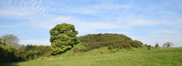
The Brú na Bóinne Research Project is part of an on-going collaborative research initiative designed specifically to address the nature and function of selected monuments within the broader landscape of the Brú na Bóinne UNESCO World Heritage Site through the exclusive use of non-invasive survey techniques. The project also serves as a vehicle for the instruction of postgraduate students of archaeology undertaking studies at the National University of Ireland, Galway, in the use and application of scientific survey techniques and associated software.
"Repopulating the archaeological landscape of the Brú na Bóinne World Heritage Site"
A vodcast of a talk given as part of the Spring Lunchtime Lecture Series on 13 March 2015
Knowth Area 10
|
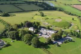
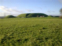
Aerial view ofKnowth passage tomb
Knowth Area 10 electrical resistance survey |
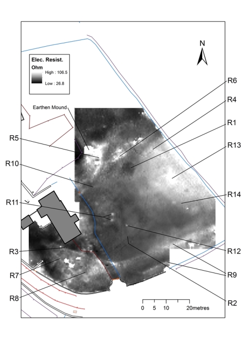 |
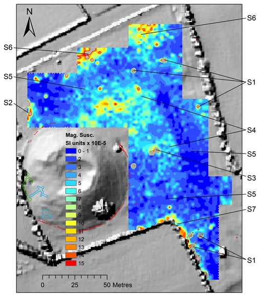
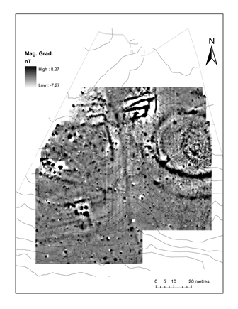
A detailed geophysical survey employing electrical resistance, magnetic susceptibility and magnetic gradiometry was deployed over the lawn area and environs to the south and east of the farmhouse and out-buildings in Knowth Area 10 (State-owned lands to the north-east of the passage tomb cemetery) in the summer of 2016. A number of potential archaeological features were noted in this area, including the possible sub-surface remains of a passage tomb.
(This research was funded by the Office of Public Works).
Further Reading:
Fenwick, J. 2019 In search of the lost 'cromlech' of Knowth: geophysical investigations in Area 10 of the Knowth Passage Tomb cemetery, Brú na Bóinne World Heritage Site, Co. Meath. RÍocht na Midhe 30. 52-79.
Dowth passage tomb and manorial village
 |
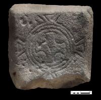
Dowth medieval cross slab.
Magnetic susceptibility survey |
Detailed topographical, magnetic susceptibility, magnetometer and electrical resistance surveys have revealed a palimpsest of archaeological features dating from the prehistoric period to the present day. The majority of surface features appear to be related to post-medieval agricultural activity, but the remains of a trackway and a series of sub-rectangular field plots which underlie it are likely to be associated with the medieval manor of Dowth. Prior to the establishment of the manor it is likely that the great mound was remodelled to function as s a motte by the Anglo-Normans. A slightly elevated, sub-rectangular platform adjoins the eastern side of Dowth passage tomb and this may be the remains of a bailey.
The existence of some prehistoric features lying undisturbed below the cultivation and medieval earthwork horizons is also a possibility. Of particular interest in this regard is the presence of a number of sizable boulders of unusual type in the field adjacent to the mound. Many of these are of a size and shape consistent with those defining the kerbs of the satellite tombs at Knowth .Two large earth-embedded stones were noted lying some 80m to the northeast of the mound and a second cluster of large boulders was also identified situated some 60m to 90m to its southeast. It is particularly interesting that these stone clusters appear to be associated with areas of high electrical resistance, suggesting the presence of zones of hard stony material lying just below the ground surface – perhaps representing the basal footprints of partially destroyed satellite tombs.
(The fieldwork at Dowth was made possible by a Royal Irish Academy archaeologial research grant with additional funds provided by an anonymous donor)
Further reading:
Fenwick, J. 2013 The landscape features, follies and antiquities of Dowth demesne. Archaeology Ireland, 27(1). 26-30.
Fenwick, J. 2015 A reassembly of the monumental fragments in Dowth townland and their significance as an integral part of the prehistoric numinous precinct of Brú na Bóinne, Co. Meath. The Journal of Irish Archaeology XXIV. 19-49.
Fenwick, J. 2017 A reappraisal of the archaeological remains in the vicinity of the great passage tomb and manorial village of Dowth, Brú na Bóinne, Co. Meath. Journal of Irish Archaeology. XXVI. 143-166.
Fenwick, J. 2019 Ever increasing circles. Archaeology Ireland, 33(2). 19-22.
Fenwick, J. 2019 Ring(s) of truth. Archaeology Ireland. 33(3), 42.
Funding:Royal Irish Academy
& anonymous benefactor
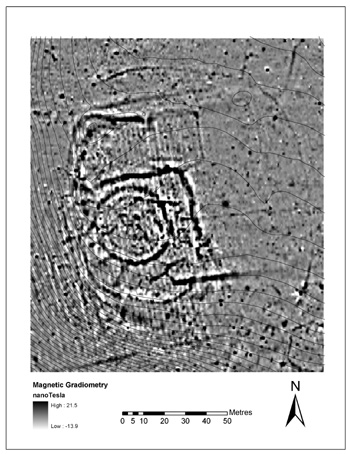
Knowth Area 11
 |
View eastwards across Knowth Area 11
Fluxgate gradiometry survey of |
A detailed archaeological survey, consisting of topographical, electrical resistance, magnetometer and magnetic susceptibility surveys of the field situated immediately to the southeast of the core area of the Knowth National Monument complex was conducted in 2011, revealing a wealth of previously unrecorded archaeological features and monuments.
The geophysical survey has identified:
A large rectangular platform or ’moated site’, measuring c. 65m north/south. This is likely to have functioned as an enclosed courtyard related to the medieval Cistercian grange activities at Knowth (The enclosure occupies the western half of the magnetometer image).
A substantial unclassified double-ditched elliptical enclosure, measuring c. 63m across its north/south axis; which might be interpreted as a ringfort, concentric enclosure, secular cemetery or double-ditched embanked enclosure or ’henge’ (occupying the eastern half of the magnetometer image). The geophysical evidence, however, would suggest that the site is more likely to have served a ritual purpose as the magnetic response from the inner enclosure displays no appreciable enhanced values (in comparison to the surrounding or background soils), as one might expect as a result of sustained habitation and related activities.
A curious series of parallel, east/west, strongly magnetic, linear anomalies, which on the basis of the geophysical evidence may be the remains of a pottery kiln or cereal-drying kiln (north-centre of the magnetometer image).
Further reading:
Fenwick, J. 2012 Geophysical survey of Knowth Area 11 (Appendix 8). In G. Eogan (with contributions by C. Johnson, M. O’Brien and others), Excavations at Knowth in the first and second millennia AD: Excavations at Knowth 5, 811-31, Royal Irish Academy, Dublin.
Crewbane souterrain and nearby archaeological features
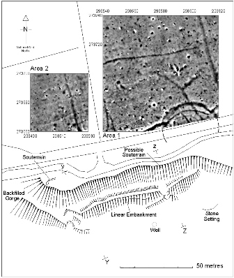 |
The survey of Crewbane souterrain.
Fluxgate gradiometry survey superimposed |
The chance discovery of a souterrain in the townland of Crewbane, Brugh na Bóinne, Co. Meath, in Novermber 2007 prompted a detailed archaeological and geophysial survey of the immediate area during which a number of additional and potentially significant archaeological features were identified. These previously unrecorded features include a second potential souterrain, a substantial earthen embankment, a low-relief linear earthwork and a well, in addition to geophysical evidence of a large circular, or sub-circular, enclosure (possibly a ringfort) and an adjacent field system. All are situated in close proximity to one another on elevated ground overlooking the River Boyne, some 200m to the south. The souterrain, therefore, appears to be just one feature within a complex of archaeological monuments located within sight of the passage tomb cemetery of Knowth, situated just 1km to the east. During the early medieval period, Knowth (ancient Cnogba) served as the royal seat of the kings of north Brega and it is likely that the archaeological complex at Crewbane forms an integrap part of its royal demesne.
Further reading:
Fenwick, J., Dowling, G., Schot, R. & Rogers, J. 2012 Crewbane souterrain and nearby archaeological features, Brugh na Bóinne, Slane, Co. Meath. Ríocht na Midhe XXIII, 1-25.
Newgrange sub-rectangular enclosure
 |
A view from Rossnaree of Newgrange
Fluxgate gradiometry survey of Newgrange |
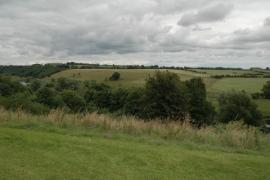
In addition to mapping the extant remains of the earthwork (RMP: ME019-065), this field research has revealed the presence of a significant complex of sub-surface archaeological features which was entirely unknown prior to the current geophysical survey. The results would suggest that a number of successive monuments were built and rebuilt at this location in order to exploit the strategic advantages of this elevated spur of ground overlooking a fording point on the River Boyne at Rossnaree.
Further reading:
Fenwick, J., Warner, R., & Eogan, G. 2009 Revealing hidden details of the ancient landscape at Newgrange, Brugh na Bóinne World Heritage Site, Co. Meath. Ríocht na Midhe XX, 5-23.
Research Funding:
Meath County Council and County Heritage Forum
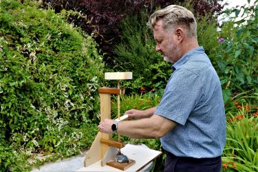
Crafting the Knowth macehead: an experimental exploration of a unique Neolithic artefact
Through an exploration of several strands of experimental archaeological research, this Royal Irish Academy-funded (RIA) project seeks to ‘reverse-engineer’ the specialist technology, methodology and innovative ingenuity that was required to craft the Knowth maesmor-type macehead, a singularly assured masterpiece of Neolithic craft and artistry. This research is being conducted in collaboration with Fred Curtis, internationally renowned crystal glass sculptor, designer and artist.
 |
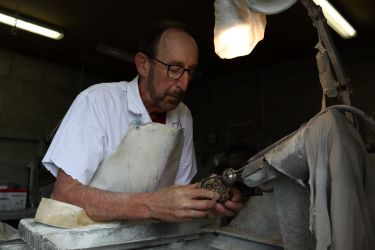 |
for more details see: 'Crafting the Knowth macehead: an experimental exploration of a unique Neolithic artefact'
Further reading:
Fenwick, J. 1995 The manufacture of the decorated macehead from Knowth, county Meath. Journal of the Royal Society of Antiquaries of Ireland 125, 51-60.
|
Awarded Archaeological Research Grants in 2022 & 2023 |